


PIX4Dfields
ซอฟต์แวร์การทำแผนที่เกษตรขั้นสูงสำหรับการวิเคราะห์พืชทางอากาศและการเกษตรดิจิตอล
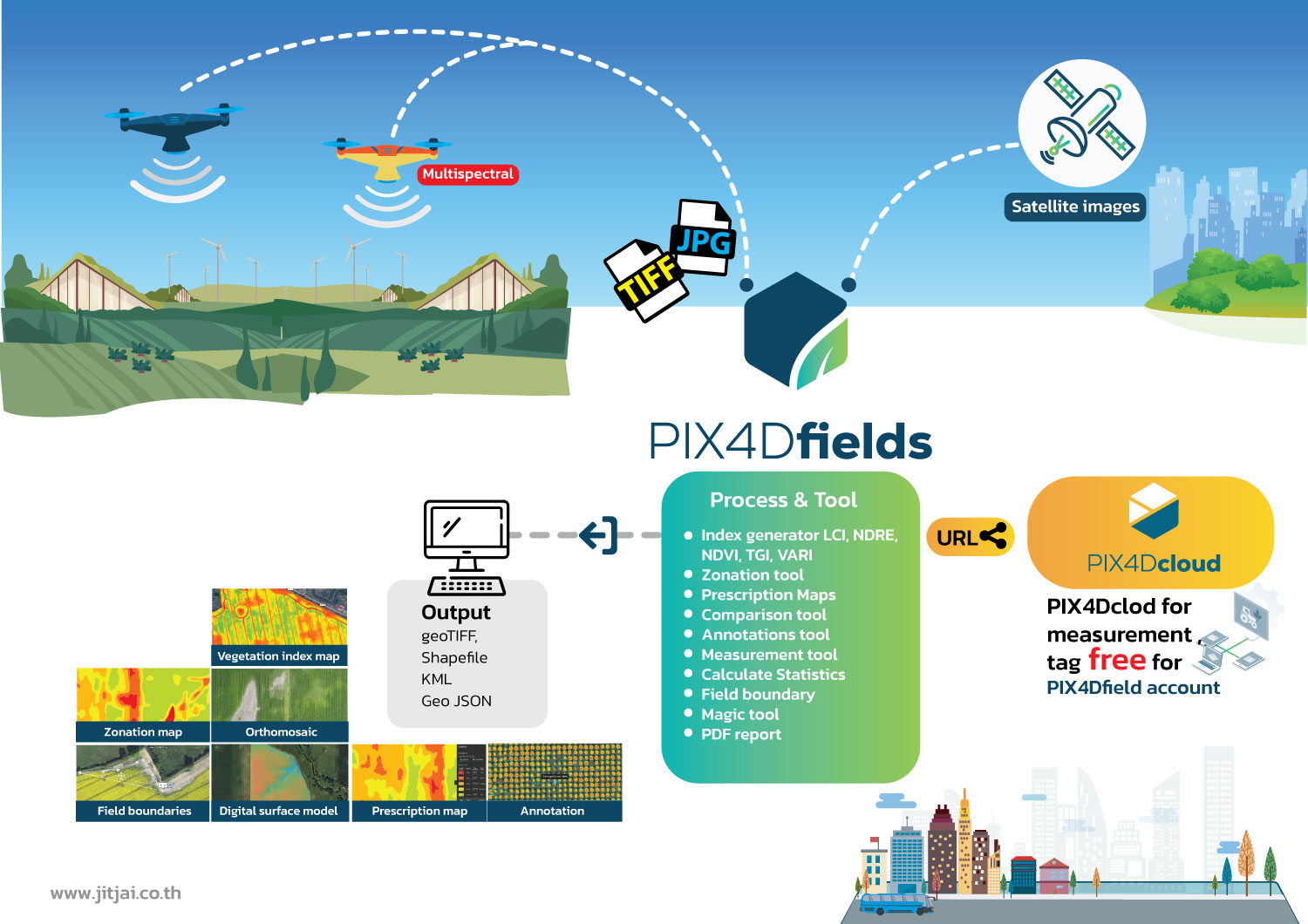
กระบวนการทำงาน
- Remote sensing : รวบรวมรูปภาพโดยใช้โดรนและกล้อถ่ายภาพ RGB หรือกล้องจับภาพความร้อน (Multispectal) รวมถึงใช้การนำเข้าข้อมูลดาวเทียมเพื่อเพิ่มประสบการณ์การทำแผนที่ของคุณด้วยข้อมูลดาวเทียม Sentinel-2
- Process : ประมวลผลภาพด้วยแบบอัตโนมัติทันทีและได้แผนทั้งหมดของคุณโดยตรงที่หน้างาน : เช่น ข้อมูลขนาด 6.8 GB, จำนวน 2948 รูปภาพ, ใช้เวลาเพียง 10 นาที
- Scout : สร้างแผนที่ orthomosaics ที่แม่นยำ, โมเดลพื้นผิวแบบดิจิตอล, แผนที่ดัชนีพันธุ์พืช, โซน และแผนที่สั่งยาที่แม่นยำ กำหนดขอบเขตพื้นที่เป้าหมายของคุณเพื่อสร้างผลลัพธ์ที่เป้าหมายมากขึ้น
- Analyze : มองเห็นและเข้าใจระยะเวลาการเจริญเติบโตของพืชและระดับความสมบูรณ์ วิเคราะห์และเปรียบเทียบข้อมูลชั้นต่าง ๆ ของพื้นผิว เพื่อให้ความเข้าใจทั้งหมดของประสิทธิภาพผลผลิตของคุณและนำมาใช้เพื่อเพิ่มผลผลิตของพืชและลดค่าใช้จ่าย
- Share : แบ่งปันแผนที่ของคุณกับผู้ที่เกี่ยวข้องในโครงการทั้งหมด แบบไร้ขีดจำกัดในการทำงานร่วมกันโดยใช้เครื่องมือรายงาน PDF หรือใช้คำสั่ง Share to PIX4Dcloud
- Integrate : ดาวน์โหลดผลลัพธ์ทั้งหมด, ผลลัพธ์และความรู้และนำเข้าในซอฟต์แวร์การจัดการเกษตรที่คุณเลือกในรูปแบบมาตรฐานของอุตสาหกรรมที่หลากหลาย
PIX4Dfields
ตรวจสอบ วิเคราะห์ และแสดงผลการเปลี่ยนแปลงของพืชของคุณตลอดทั้งปี
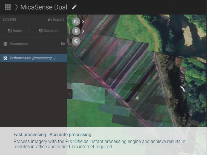
- • ประมวลผลอย่างรวดเร็ว - ประมวลผลที่แม่นยำประมวลผลภาพด้วยเครื่องประมวลผลทันทีของ PIX4Dfields และได้ผลลัพธ์ภายในไม่กี่นาทีทั้งในสำนักงานและในที่นา ไม่ต้องการอินเทอร์เน็ต
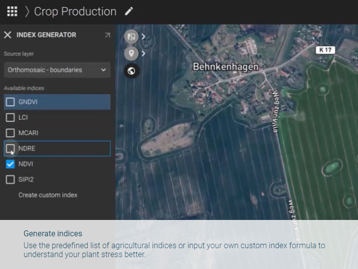
- • สร้างดัชนีใช้รายการที่กำหนดไว้ของดัชนีทางการเกษตรหรือใส่สูตรดัชนีที่กำหนดเองเพื่อเข้าใจการเคลื่อนไหวของพืชของคุณได้ดีขึ้น
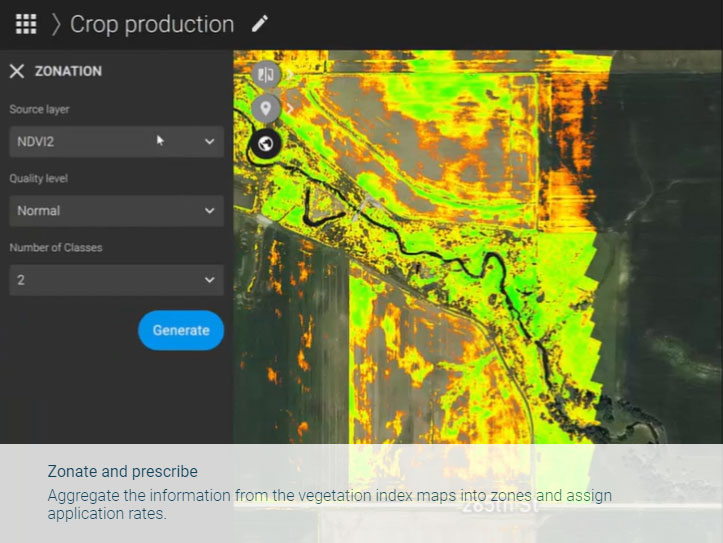
- • แบ่งโซนและจ่ายสารพัดสู่ข้อมูลจากแผนที่ดัชนีพืชลงในโซนและกำหนดอัตราการใช้
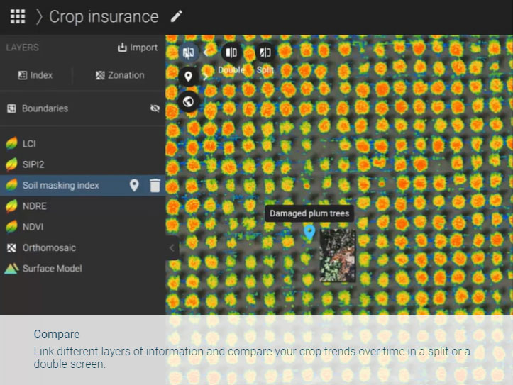
- • เปรียบเทียบเชื่อมโยงชั้นข้อมูลที่แตกต่างกันและเปรียบเทียบแนวโน้มของพืชของคุณตลอดเวลาในหน้าจอแบบแยกหรือหน้าจอแบบคู่
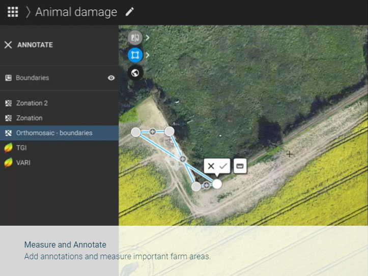
- • วัดและทำเครื่องหมายเพิ่มหมายเหตุและวัดพื้นที่ที่สำคัญในฟาร์ม
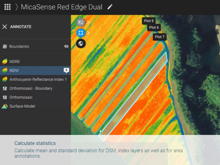
- • คำนวณสถิติคำนวณค่าเฉลี่ยและค่าเบี่ยงเบนมาตรฐานสำหรับ DSM, ชั้นดัชนีรวมทั้งสำหรับหมายเหตุพื้นที่
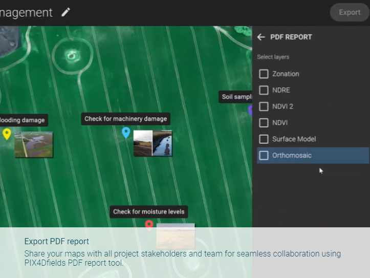
- • ส่งออกรายงาน PDF แบ่งปันแผนที่ของคุณกับผู้ที่เกี่ยวข้องในโครงการทั้งหมดและทีมของคุณให้สามารถร่วมมือได้อย่างไม่มีช่องว่างในการใช้เครื่องมือรายงาน PDF ของ PIX4Dfields.
การใช้ PIX4Dfield ในการวางแผนการพ่นยาฆ่าแมลง ช่วยประหยัดงบถึง 60%
Download Brochure
ดาวน์โหลดPIX4Dfield
Output
Generate high resolution outputs for any project and use case Easily export your digital maps and models to industry-compatible formats for further analysis or reporting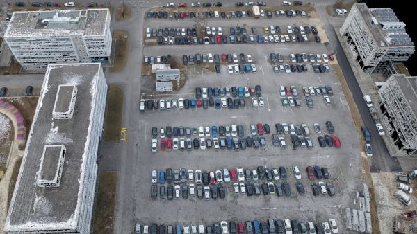
Color point cloud
The color point cloud uses RGB data from a raster for colorization. Each point of the point cloud receives the RGB value of the raster pixel that has the same location.Output formats: .las, .laz, .ply, .xyz
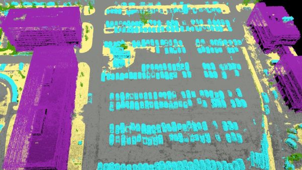
Classified point cloud
The point cloud is classifed in 5 predefined groups: ground, road surface, high vegetation, building, human made object. The results of the classification are used for the DTM generation.Output formats: .las, .laz
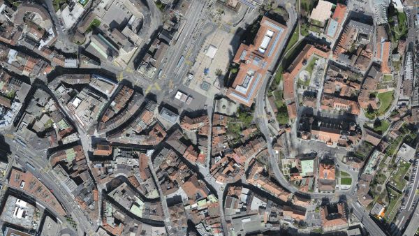
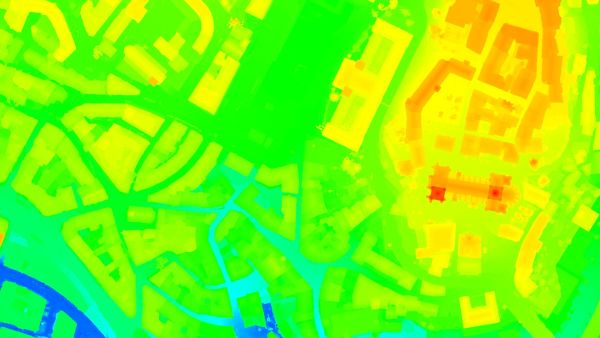
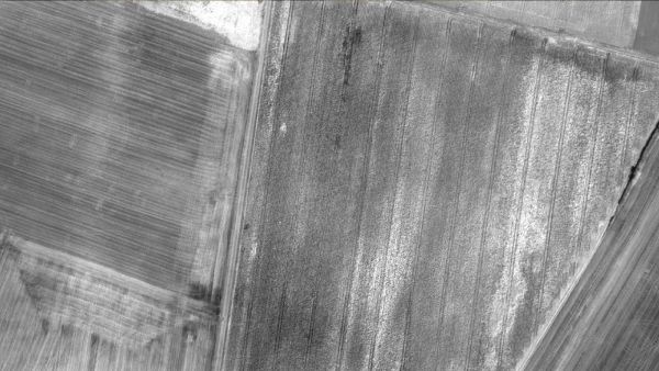
Orthomosaic
2D image map geometrically corrected such that the scale is uniform. Color balanced to be visually pleasing.Output formats: GeoTiff (.tif), .kml
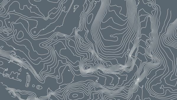
Contour lines
These are lines connecting points of equal elevation. They allow to better understand the shape of the land surface (the topography) on a map.Output formats: .shp, .dxf, .pdf
Digital terrain model (DTM)
Digital elevation model (DEM)
2.5 D model of the mapped area after filtering out objects such as buildings, that contains (X,Y,Z) information but no color information.
Output formats: GeoTiff (.tif)
Digital surface model (DSM)
2.5 D model of the mapped area that contains (X,Y,Z) information, but no color information.Output formats: GeoTiff (.tif), .xyz, .las, .laz
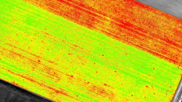
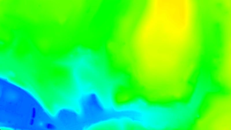
Index maps
Each index is associated to an index map. For each pixel on this map, the value of the pixel is derived from the associated reflectance maps.Output formats: GeoTiff (.tif), .shp
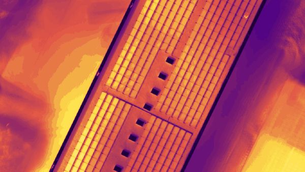
Thermal maps
Thermal maps are 2D maps displaying the thermal information from infrared imaging cameras for each pixel.Output formats: GeoTiff (.tif)
Reflectance maps
A reflectance map compiles the reflectance values of each pixel and geometry into a single function.Output formats: GeoTiff (.tif)
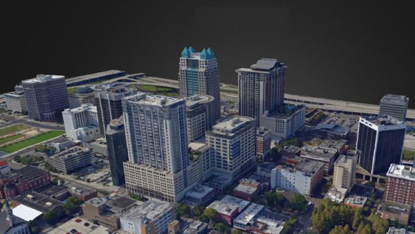
3D textured mesh
A representation of the shape of the model that consists of vertices, edges, faces and the texture from the images that is projected on it..Output formats: .ply, .fbx, .dxf, .obj, .pdf
GET SPECIAL OFFER !!!
รับราคาพิเศษ สำหรับ License แบบซื้อขาดและแบบรายปี กรอกแบบฟอร์มเพื่อขอใบเสนอราคาได้เลย
ขอใบเสนอราคาพิเศษ