


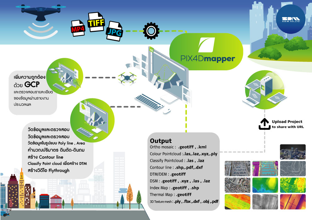
PIX4Dmapper
ซอฟต์แวร์โฟโตแกรมเมทรีชั้นนำสำหรับการทำแผนที่โดรนระดับมืออาชีพ ตัวโปรแกรมให้ผลลัพธ์ระดับ Survey grade มี work flow ที่เข้าใจและทำงานง่ายสำหรับผู้เริ่มต้นใช้งานทำให้ได้ผลลัพธ์ที่ครอบคลุม และสำหรับผู้ใช้งานระดับมืออาชีพสามารถกำหนด template และตั้งค่าการประมวลผลได้ด้วยตนเอง
รองรับข้อมูล
- Aerial (nadir & oblique)
- terrestrial imagery
- รองรับกล้องทุกรุ่น (compact, SLR,multispectral, GoPro) ในรูปแบบไฟล์ .jpg หรือ .tif


PIX4Dmapper
คุณสมบัติของตัวโปรแกรม PIX4Dmapper
- • ตัวโปรแกรมเป็นแบบ Floating license สามารถติดตั้งได้หลายเครื่องคอมพิวเตอร์แต่จะสามารถล็อคอินเข้าใช้งานได้ทีละ 1 เครื่อง
- • สามารถนำเข้า Point Cloud จากแหล่งต่างๆเพื่อนำไปสร้างข้อมูล DSM และ Orthomosaic กับข้อมูลในโครงการเดียวกันได้
- • นำเข้าข้อมูล GCP จากเครื่องมือสำรวจในรูปแบบค่าพิกัด XYZ ที่อยู่ในรูปแบบ csv , txt เพื่อเพิ่มความถูกต้องของข้อมูลได้
- • นำเข้าภาพที่ถ่ายด้วยกล้องหรือโดรนที่เป็นหลายๆช็อตมาประมวลผลและต่อกันให้เป็นภาพผืนเดียวหรือที่เรียกว่า Orthomosaic
- • มี Template รองรับการทำงานที่หลากหลายให้เลือกในการประมวลผล
- • มีการประมวลผลแบบ Rapid Process พร้อม Quality Report สำหรับการประมวลผลแบบเร็วเพื่อตรวจสอบข้อมูลหน้าไซต์งาน
- • สร้างข้อมูล Orthomosaic ในรูปแบบ GeoTIFF และ Google tiles ในรูปแบบ .kml , .html ได้
- • สร้างข้อมูล Point Cloud และ classify Point Cloud ในรูปแบบ .las, .laz, .xyz และ .ply ได้
- • สร้างข้อมูล 3D Texture mesh ในรูปแบบ .obj, .ply, .dxf, .fbx และสามารถสร้าง 3D pdf ได้
- • สามารถสร้างข้อมูลความสูงภูมิประเทศในรูปแบบข้อมูล DSM และ DTM ในรูปแบบ GeoTIFF ได้
- • มีฟังก์ชั่นในการวัดแบบ Polyline, Polygon , volume calculate
- • สามารถสร้าง VDO Animation ของข้อมูล 3D mesh ในรูปแบบ MP4 เพื่อช่วยในการนำเสนอข้อมูลได้
- • สามารถสร้าง Index maps (Thermal, DVI, NDVI, SAVI, etc.) ในรูปแบบ GeoTIFF และ GeoJPG ได้
- • สามารถสร้าง Prescription maps ในรูปแบบ .shp ได้
- • สร้างเส้นชั้นความสูง Contour line ในรูปแบบ .shp, .dxf, .pdf ได้
Download Brochure
ดาวน์โหลดPIX4Dmapper
Output
Generate high resolution outputs for any project and use case Easily export your digital maps and models to industry-compatible formats for further analysis or reporting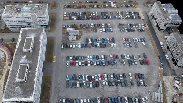
Color point cloud
The color point cloud uses RGB data from a raster for colorization. Each point of the point cloud receives the RGB value of the raster pixel that has the same location.Output formats: .las, .laz, .ply, .xyz
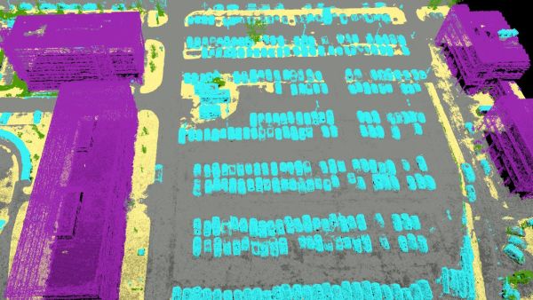
Classified point cloud
The point cloud is classifed in 5 predefined groups: ground, road surface, high vegetation, building, human made object. The results of the classification are used for the DTM generation.Output formats: .las, .laz
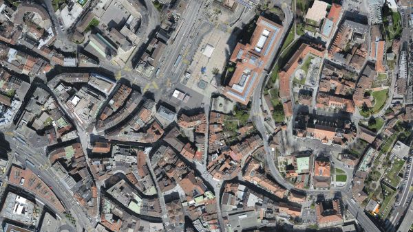
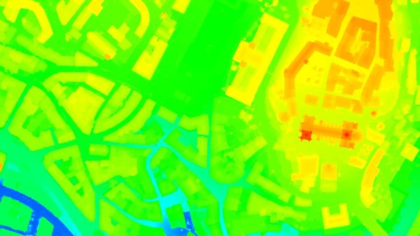
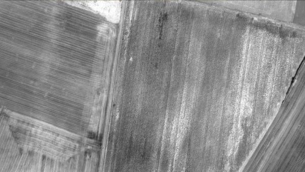
Orthomosaic
2D image map geometrically corrected such that the scale is uniform. Color balanced to be visually pleasing.Output formats: GeoTiff (.tif), .kml
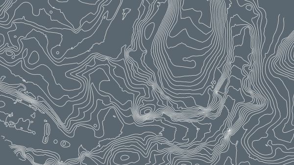
Contour lines
These are lines connecting points of equal elevation. They allow to better understand the shape of the land surface (the topography) on a map.Output formats: .shp, .dxf, .pdf
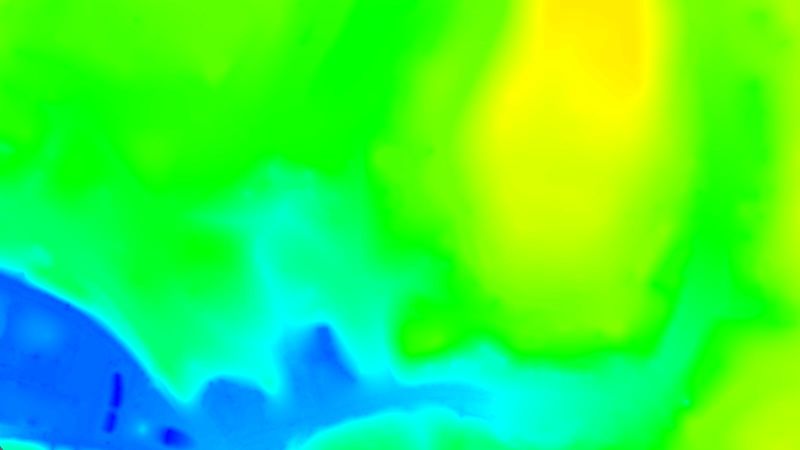
Digital terrain model (DTM)
Digital elevation model (DEM)
2.5 D model of the mapped area after filtering out objects such as buildings, that contains (X,Y,Z) information but no color information.
Output formats: GeoTiff (.tif)
Digital surface model (DSM)
2.5 D model of the mapped area that contains (X,Y,Z) information, but no color information.Output formats: GeoTiff (.tif), .xyz, .las, .laz
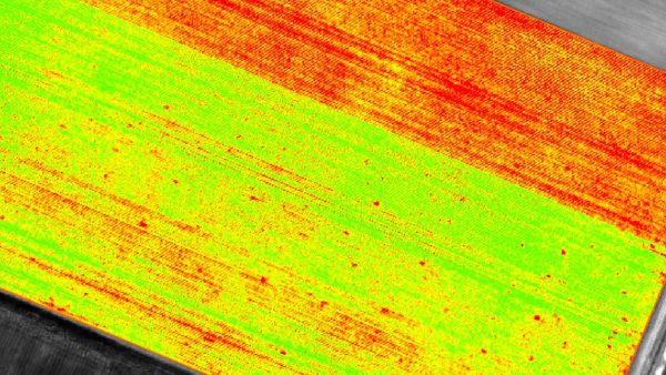
Index maps
Each index is associated to an index map. For each pixel on this map, the value of the pixel is derived from the associated reflectance maps.Output formats: GeoTiff (.tif), .shp
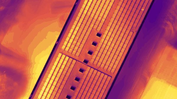
Thermal maps
Thermal maps are 2D maps displaying the thermal information from infrared imaging cameras for each pixel.Output formats: GeoTiff (.tif)
Reflectance maps
A reflectance map compiles the reflectance values of each pixel and geometry into a single function.Output formats: GeoTiff (.tif)

3D textured mesh
A representation of the shape of the model that consists of vertices, edges, faces and the texture from the images that is projected on it..Output formats: .ply, .fbx, .dxf, .obj, .pdf
GET SPECIAL OFFER !!!
รับราคาพิเศษ สำหรับ License แบบซื้อขาดและแบบรายปี กรอกแบบฟอร์มเพื่อขอใบเสนอราคาได้เลย
ขอใบเสนอราคาพิเศษ